
Tags
There are people about today: playing in teams with some kind of throwing thing on the beach; splashing in the water where Mummaga Lake enters the sea with a rush; fishing placidly from the rocks; clambering around with bucket and spade; picnicking on the grass; watching an infant take her first steps; and staggering around watching every footfall amongst the pools and slashes of rock poking out of the sand, camera at the ready.
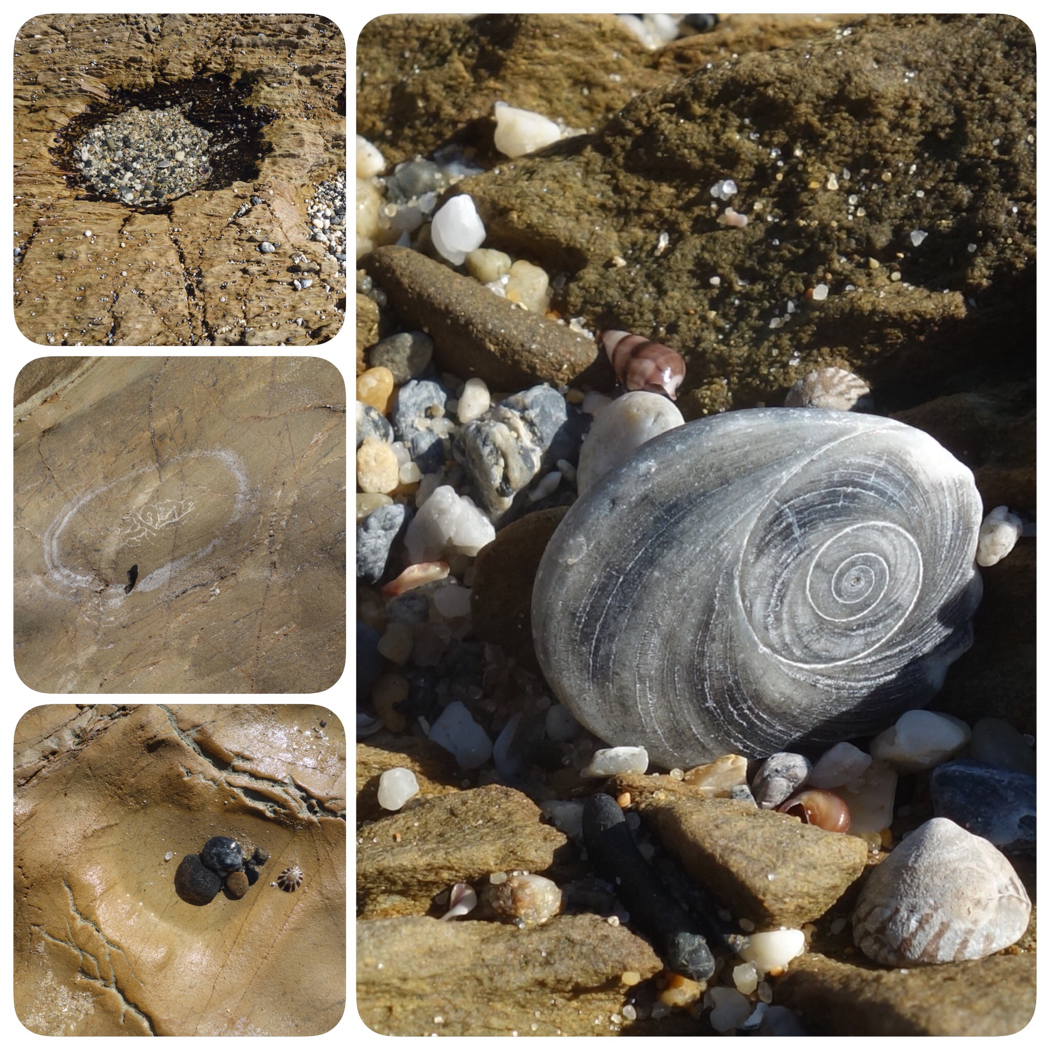
This beach is just in front of a caravan park, still occupied by school holiday makers. It’s the peak of low tide, so the rocky platform is exposed and the sand firm. This is my third unfamiliar beach in a week, and they couldn’t be more different. What is the essence of this one? Shingle consisting of bigger shells than I saw at Plantation Beach, or McKenzies. Rocks piled up into a rounded turret or weathered to the shape of Opera House sails. Seams of white quartzlike rock wandering their way through the surface and crevices of their host. Narrow vertical ridges. Gleaming mustard-yellow slabs with smooth hollows. Rockpools, and rock-dimples filled with shells.


That’s my narrow world, at noon on a particular day. But there are other worlds here too.
Geology has been busy for eons, shaping the shoreline and its beauties, making it unique. Weathering and the repetitious action of the sea are co-creators of all the shapes and patterns that have given pleasure to the tiny dot in the universe that is me.
Yuin Elder, YIrrimah evokes the Aboiginal world: “We’ve got totems here. Our sisters swim through the rocks. The whales, the seabirds, eels, crabs, they’re our family.” An information board lists Aboriginal names: maara maara, waagal, junga, yannga, bimbulla, wondarma, mingo. (What whitefellas call sea mullet, blackfish, octopus, lobster, Sydney cockles, appleberry, grass tree.)
Migrating Humpback whales come in close to shore on their long journey north to breed in the tropics in winter and then back to the Antarctic summer feeding grounds. If you’re lucky you can see them spouting and breaching, sometimes mother and baby playing together.
William Mort brought the whitefella world of sheep and dairy cows here in the 1880s. He settled land behind the beach and along Mummaga Lake, now State Forest and the suburb of Dalmeny, named by him after his Eton schoolfriend who became Lord Dalmeny, an obscure British Prime Minister.
Intrepid camping holiday-makers began coming in the 1920s, although by then Narooma just down the coast was a holiday destination with some pretty classy guest houses. This influx continues: a number of people I meet holiday here for years before they make it their retirement home, and the population swells dramatically over summer.
And then there are the current holiday makers, grabbing the last of the warmth, and me on my mission to visit every beach in the shire.

Dalmeny is the next beach down from Potato Point: to access it take the Tourist Drive turnoff from the Princes Highway about 8 kilometres south of Bodalla, until you reach the caravan park. There’s some confusion about the name. My coastal bible, Beaches of Batemans Bay and the Eurobodalla Coast by Peter and Manuela Henry, calls the northern part Brou Beach with Dalmeny in brackets: and the southern part (where I photographed for this post) Josh’s Beach. Names in this coastal strip seem to be mutable.

Love your posts. We are very fortunate to live here, and get to witness the ever changing seascape every day
LikeLike
We are indeed!
LikeLike
Hello my dear, I envy you your beaches, they are spectacular and your collages are a wonderful showcase for your definitely not narrow world!
LikeLike
I love visiting your beaches. This one has such textures and patterns. Love the spiral. That image stood out for me.
LikeLike
Oh I love this beach, look at all those textures. And the name itself — Eurobodalla — is pure poetry.
LikeLike
Dalmeny isn’t half as euphonious.
LikeLiked by 1 person
I like the detailed photos of rocks – I tried to figure out which ‘set’ appealed the most. I think I got the numbers right – group 7 and 8 or maybe it’s 6 and 7. I mean the ones of the light brown rocks with the lighter lines on them anyway. 🙂
The photo that stood out of the whole collection for me was the one with white spiral on a grey rock. I’m guessing it’s one of those tiny little shells that form the suction cap for a type of mollusc but the way you have honed in on it takes it to a new place. It would make a lovely etching.
LikeLike
I’ll have to start numbering photos – collages make it even harder to keep track. I love rockface, such differences on the same beach and between beaches. A little more geological knowledge at the macro level would be handy. But the aesthetics are very satisfying.
LikeLiked by 1 person
I agree about the geological knowledge. I have been wishing I knew more a lot lately. Maybe that should be the focus – a bit of detailed research. 🙂
LikeLike
Thanks for this Meg our cousin R M lives in that area. I thought it was more inland. I guess I learn something new every day. Loved the photos. SO much I have never seen before.
LikeLiked by 1 person
You’re not the only one: and you haven’t lived here for 40 years!!
LikeLike